
|
The Trails of Copper Canyon Beckon
This Pamachi hike is something that’s been in the works for a long time. Guaguevo, while more remote distance-wise is actually less remote being a Mestizo town. When we got there in 2008, we found out that the road from Samachique (at the highway turnoff) had beaten us by 2 years. We arrived there on a Palm Sunday. We hiked up from the Rio Urique and watched the festivities. Segregated throngs of Tarahumaran men and women listened as interested but distinct groups, while the village gobernador spoke in the church doorway. Ringing the walls of the church, Mexicans leaned against their vehicles, beers in hand. They watched us almost more curiously than they watched the Indians. Years later, when we arrived at Gueguevo overland from Pamachi, some people remembered the chabochi couple who came up from the river for the afternoon. It was the stuff of legends.
Pamachi as approached from the river is much more remote, the people are much more shy and reticent to have conversations with strangers, and the town is no more than a school, a church, and the requisite Diconsa/Conasupa government stocked rural store. It appeared the road into town was a fork off the main road to Guaguevo because while we were there there was no traffic, and nobody even owned a vehicle except for one yard where a derelict pickup rested on blocks.
We found a new route down to the river for this hike. To say that the canyons beckon is an understatement. Whiling away the day-to-day in Tucson during the off-season gave us the opportunity to imagine new hikes and destinations when we got back to the canyons. We had an inkling that this route went, but we had no idea it as so easy. Then, when we returned after the rains, we were amazed that the route was so hard. The trail was indistinguishable, choked with a thick mat of vines. The steep scree hillside was sliding away under our feet. In fact, if we hadn't just done it 6 months before we would have given up. By now, we realized that there was no way to reach the river but we remembered that there was a spring at what would now be tonight's camp. What we had done in 6 hours in March, took us 2 days in October. Talk about the stuff of legends…
 |
Once we exited the jungle, hiking along the river was refreshing to say the least. Wide open bends, flat inviting sandbars, and rocky angular benches beneath 1000 foot lush green mountainous buttresses flanked the wide, meandering Rio Urique. There were several fords to negotiate as we positioned ourselves for the ascent at what we hoped was the proper arroyo. An all-but-invisible ancient stone lookout guarded the entrance. Inside we found a pickaxe, worn down by years of use to less than half it's normal size. But sure enough, a distinct trail led uphill. Once the narrow arroyo widened, the trail branched in a mesh of trails best understood by browsing cows or grazing goats. We developed a sense of understanding of the main route. If a branch brushed our packs, we looked around for another fork. The main burro-packing camino had more clearance than the routes for foraging. Hours later, we heard someone chopping wood. A Tarahumaran was working on a corral. He was surprised to see us, but indicated out destination was up ahead. The canyon eventually boxed us in and we had to bushwhack. We encountered vestiges of goat and cattle trails as we climbed.
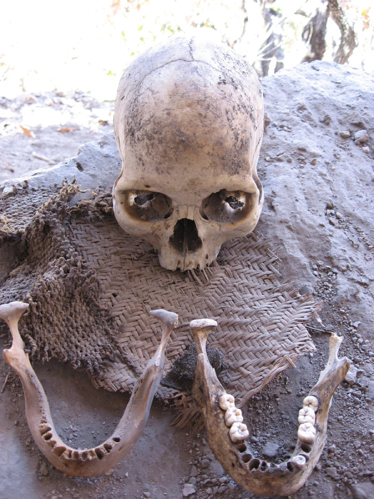
There were some bones mixed in with the loose scree as we climbed. We thought a cow had lost it's footing and decomposed, until we noticed a human skull wedged under a root. We found a burial cave high up on the precarious slope with a skull and 3 mandibles, and this was without digging around; just stuff we found rolling around on the surface. It looked like the stucco that for generations had cemented the remains under the rock overhang had eventually eroded the interment. Bad Ju-ju to hang around. We moved on. Higher up the slope was a series of rock dwellings in the overhang of a huge cliff. Large baskets and bateas were on the dirt roof to protect them from animals, but people of course could climb the walls to get to the roofs. There was a walled up structure with a fitted door and a lock. We traverse to the side on a well worn path and found a springs, and further on, an inhabited dwelling. The inhabitants hid inside and wouldn’t come out once it became obvious that we desired a conversation. Their dwelling was on a cul-de-sac that maybe didn’t offer an ascent through the pinnacles to Pamachi.
 |
We traversed the other direction, around the edge of a ridge, and at a junction ascended a series of switchbacks to a field with a large balanced rock. The area had stone structures built on top of 2 large boulders. Most of the scrub oaks had recently been cut. Here we traversed, gently ascended to the south, past another spring, through a break in the cliff, and ended up circumnavigating a mesa. We came practically full circle on this mesa at a saddle with cliff dwellings on both sides. A wall to our progress was actually a rock saddle with carved footholds. A gentle north ascent led to a Tarahumara ladder, and a short but steep route took us back through the same rock layer, this being the 3rd time through that layer! Confusing!! On top of this layer was a long, easy traverse on well worn rock trails with lots of carved footholds to the Pamachi plain- Mesa Rohuerachi. We contoured right but a straighter up-and-down route would have carried us to the village center- "la mission Pamachi". The contour led us to the Arroyo Pamachi which forced us back up to the village. The locals surreptitiously watching us were probably laughing their fool heads off watching the newcomers spin around willy-nilly like we were in a maze.
Nodody was about, but you could see that school was in session, and the classrooms were full of kids. We asked a group of kids at the schoolyard fence if there was a store. They pointed to a small squat structure right beside us made of heavy notched squared off beams. It was as big as a corn crib, but it had a door, and the door was opened. It was dark inside. Actually is was pretty cloudy outside so it wasn’t too light there either. We stepped inside and there were a couple of guys on either side of a counter. They had been watching us from the shadows. We ordered a couple of sodas, suitably chilled by the cool, dank shack. We stepped out to drink. Curiously enough, now we started to see people. A couple of guys came around the corner of the shack and went inside. A little Tarahumaran girl in flowing filthy skirts ran up clutching a handfull of clanking coins. Just then a CRACK! opened up the sky, and it started pouring rain. We tried to get under the tiny overhang but the roof leaked and the wind was blowing. We squeezed inside with all the others; leaning way over to find wall space as the floor was strewn with cases of soda bottles, galvanized buckets, stacks of Maseca ground corn, and various ranch necessities like wire staples, rawhide strips and cowboy shirts. More people squeezed in who had been caught out in the rain. They all exchanged pleasantries with the locals, and quizzical looks with us. We said hello to each and every one as we rotated around to give everyone a turn at the counter. Thankfully the rain finally slackened, and we could step outside.
 |
We hoisted up our mud splattered packs, and went over to the overhang of the church roof to take a look at the map, and plan our next move. There really wasn’t that much more to town. On the far side of the school was a government looking building with a fence around it and a big antenna on top. A muddy rutted road went up a nearby hillside. A truck without tires rested on blocks on uneven ground. The high side was about two feet off the ground. The low side acted as a dam for the mudflows that had come through town since it had quit running. That was about it except for a Mexican looking house make of cement blocks across the road from the store and the school. Typical of the Indians’ preference for solitude, all the ranchos we had passed coming into town were just barely out of sight of each other, and from where we stood only the roof of another house was visible.
We were just heading out of town when we were swamped by two dozen kids getting out of school. We opened a bag a crackers and passed them around, and took some photos as we left. We were aiming for the Mesa Samarachi, a junction at the Hot Springs Camino Real tip-off, still 1.5 hours away. Now the sun was out blinding-white in a fresh-scrubbed sky recently cleaned by a hard rain. The dust and smoke had settled, and you could see for miles on this high mesa.
The rest of the route was know territory for us. Just over the far ridge was a mojonera that we had used on previous hikes. This mesa on the map is the high ground between the Batopilas and Urique drainages. It has lots to offer. You can access it from the highway at Samachique, right at the Batopilas turnoff. From there Pamachi is only 40 kilometers on pleasant 4WD dirt roads. It's better to hike, or go by horse. That hike will have to wait for another time.